This is a 60+ page book by the Upper Allen Heritage Committee published in 1976. A copy is available at the Fredricksen Library. The Chairmen of the Committee at the time were Joseph B. Bittenbender, M.D. and Edward F. Lafond, Jr.
The cover of the book depicts the 1858 map of Cumberland County as confirmed by a copy in the Pennsylvania State archives. If you look closely in the lower right corner of the cover, above “by the Upper Allen Heritage Committee”, you will see the “M Lambert” homestead as well as the “J Scherich” and “W Lambert” homesteads. We also see that there was a “Sand Stone Quarry” near the “G & S Mill” and that there was “J Hickernel Brick Yd” between the Scherich and W. Lambert homesteads. This explains where the brick for area farmhouses and barns came from. We also see that the area near the eastern end of McCormick and Lisburn Rds. was called “Scherich’s Fording”.
From the Introduction to Early Architecture in Upper Allen Township:
“The Heritage Committee was officially authorized by the township Commissioners in 1973 and specifically charged with planning the local bicentennial celebration. The charter members, however, conceived of it in an additional and broader sense as an ongoing vehicle for the study of the township’s historical and cultural heritage.”
“Responding to this interest, a task force was named by the heritage committee in 1974 to undertake the ambitious project of studying detail and carefully cataloging every structure in any way recognizable as being in existence prior to 1860. To our knowledge, no such project has previously been undertaken on a township – wide basis in Pennsylvania.”
“Although the cut off date of 1860 may seem capricious, there are several reasons for choosing it. First, the Cumberland County map of 1858 places each homestead and gives the names of its owner. Second, the Civil War largely marked the end of an era during which vital components of a house were handcrafted on the site. Thereafter machine milling of woodwork became common. Finally, regional differences in building styles were almost completely obscured after this date.”
In a flashback to our political past, we learn in the Historical Notes that there were “election riots” in 1740 and “other events convinced the proprietary authorities that the two groups were essentially immiscible, and it was decided to set aside the new county of Cumberland as an exclusive Scot-Irish preserve”.
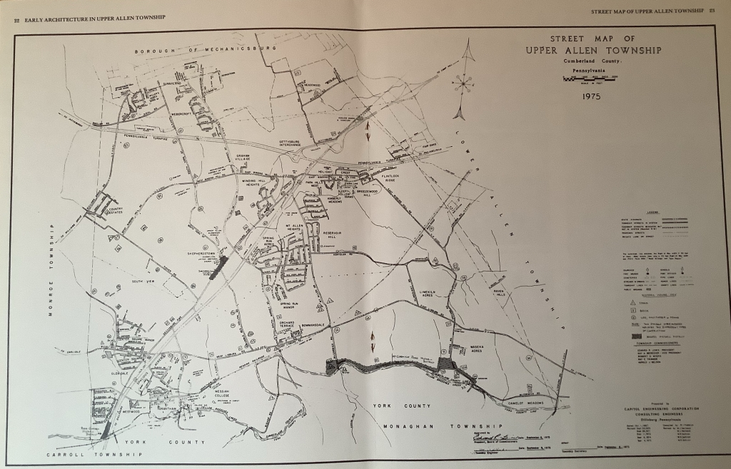
Early Architecture in Upper Allen Township became the basis for establishing the township Historic Districts; Rosegarden, Shepherdstown, and McCormick Rd. appear on a 1975 map shown on pages 22-23.
Pages 42-47 provide a full “Catalog Of Historic Buildings in Upper Allen Township”. The historic properties listed on McCormick Rd. are as follows:
35 Michael & Mary Lambert Homestead 1855
35a Lambert Barn ca 1825-30
34 Hugh Laird Miller’s House ca 1770-1820
33 Lantz Mill ca 1830
32 George Lantz Homestead 1831
32a Lantz Summer Kitchen ca 1830
32b Lantz Barn ca 1830
30 Abraham Wagner or Lantz Mill Tenant House ca 1780
29 Allen Garage
25 Nauman’s Bridge
24 Spring House
23 Michael Cocklin Homestead 1841
Others not listed in Early Architecture of Upper Allen:
+ Mill Bridge 1918
++ 443 McCormick Rd. ca 1850